ContactPost: Ortiješ bb, P.P. 133 Tel:+387 36 446 224 Fax:+387 36 446 261 Email:aisbih@bhansa.gov.ba | AIC for BOSNIA AND HERZEGOVINA | AIC A 001/2022 Effective from 21 APR 2022 Published on 21 APR 2022 |
ContactPost: Ortiješ bb, P.P. 133 Tel:+387 36 446 224 Fax:+387 36 446 261 Email:aisbih@bhansa.gov.ba | AIC for BOSNIA AND HERZEGOVINA | AIC A 001/2022 Effective from 21 APR 2022 Published on 21 APR 2022 |
| Post: | Ministry of Communications and Transport Directorate of Civil Aviation V kozarske brigade 18 78000 Banja Luka Bosnia and Herzegovina |
| Phone: | +387 51 921 222 |
| Fax: | +387 51 921 520 |
| E-mail: | bhdca@bhdca.gov.ba |
| URL: | http://www.bhdca.gov.ba |
| Office | Hours of Operation | Telephone | Telefax | AFTN |
|---|---|---|---|---|
| ARO Banja Luka | H24 | +387 51 337 537 | +387 51 337 538 | LQBKZPZX |
| ARO Sarajevo | see NOTAM | +387 33 779 150 | +387 33 546 743 | LQSAZPZX |
| ARO Mostar | see NOTAM | +387 36 352 209 | +387 36 352 208 | LQMOZPZX |
| ARO Tuzla | see NOTAM | +387 35 745 530 | +387 35 745 532 | LQTZZPZX |
| RCC Banja Luka | Hours of Operation | Telephone | Telefax | AFTN |
| H24 | +387 1262 +387 51 337 564 +387 61 260 831 | +387 351 337 566 | LQSBYCYX LQSBYCYX |
| IFR | VFR | |
|---|---|---|
| IFR from IFR, IFR from VFR | Separation | VFR from IFR |
| Air Traffic Control Service | Service provided | a) ATCS for separation from IFR, b) VFR/VFR traffic information (and traffic avoidance advice on request) |
| Not applicable | VMC visibility and distance from cloud minima | At and above 10 000 FT: - 8 KM visibility - 1.500 M horizontal and 300 M vertical distance from cloud Below 10 000 FT: - 5 KM visibility - 1.500 M horizontal and 300 M vertical distance from cloud |
| Not applicable | Speed limitation | 250 KT IAS below 3050 M (10000 FT AMSL) |
| Continuous two-way | Continuous two-way | |
| YES | ATC Clearance | YES |
| IFR | VFR | |
|---|---|---|
| IFR from IFR | Separation | NIL |
| Air Traffic Control Service, Traffic information about VFR flights (and traffic avoidance advise on request) | Service provided | IFR/VFR and VFR/VFR Traffic information (and traffic avoidance advise on request) |
| Not applicable | VMC visibility and distance from cloud minima | At and above 10 000 FT: - 8 KM visibility - 1.500 M horizontal and 300 M vertical distance from cloud Below 10 000 FT: - 5 KM visibility - 1.500 M horizontal and 300 M vertical distance from cloud |
| 250 KT IAS below 3050 M (10000 FT AMSL) | Speed limitation | 250 KT IAS below 3050 M (10000 FT AMSL) |
| Continuous two-way | Continuous two-way | |
| YES | ATC Clearance | YES |
| IFR | VFR | |
|---|---|---|
| IFR from IFR | Separation | NIL |
| Air Traffic Control Service and as far as practical, Traffic information about VFR flights | Service provided | Traffic information as far as practical |
| Not applicable | VMC visibility and distance from cloud minima | At and above 10 000 FT: - 8 KM visibility - 1.500 M horizontal and 300 M vertical distance from cloud Below 10 000 FT: - 5 KM visibility - 1.500 M horizontal and 300 M vertical distance from cloud |
| 250 KT IAS below 3050 M (10000 FT AMSL) | Speed limitation | 250 KT IAS below 3050 M (10000 FT AMSL) |
| Continuous two-way | NO | |
| YES | ATC Clearance | NO |
| IFR | VFR | |
|---|---|---|
| NIL | Separation | NIL |
| NIL | Service provided | FIS |
| NIL | VMC visibility and distance from cloud minima | At and above 10 000 FT: - 8 KM visibility - 1.500 M horizontal and 300 M vertical distance from cloud Below 10 000 FT: - 5 KM visibility - 1.500 M horizontal and 300 M vertical distance from cloud At and below 3000 FT AMSL or 1000 FT AGL, depending what is higher: - 1.5 KM visibility - clear of cloud and in sight of ground or water Remark: 800 M for Rotorcraft, Air Ships and Free Balloons. Additionally: Adequate opportunity to observe obstacle on time shall exist. |
| NIL | Speed limitation | 250 KT IAS below 3050 M (10000 FT AMSL) |
| NIL | NO | |
| NO | ATC Clearance | NO |
| Class | C | D | E | G |
| Radio station | Mandatory | Mandatory | Mandatory | Recommended |
| VOR | Recommended | Recommended | Recommended | |
| SSR Transponder | Mandatory | Mandatory | Recommended | |
| GPS Receiver | Recommended | Recommended | Recommended | Recommended |
| Meteorological office | Phone | Fax | |
|---|---|---|---|
| 1 | 2 | 3 | 4 |
| |||
| SARAJEVO1 | +387 33 779 153 +387 63 352 586 | +387 33 546 743 | sarajevo.met@bhansa.gov.ba |
| BANJA LUKA2 | +387 51 337 573 +387 61 260 631 +387 63 353 224 | +387 51 337 571 | banjaluka.met@bhansa.gov.ba |
| MOSTAR1 | +387 36 352 207 +387 61 260 176 | +387 36 352 208 | mostar.met@bhansa.gov.ba |
| TUZLA1 | +387 35 745 746 +387 63 351 665 | +387 35 745 532 | tuzla.met@bhansa.gov.ba |
| Name of station | Call Sign/ IDENT (EM) | FREQ | Broadcast period | Hours of service | FIR, Aerodromes included | REP, FCST SIGMET and Remarks |
|---|---|---|---|---|---|---|
| 1 | 2 | 3 | 4 | 5 | 6 | 7 |
| ||||||
| BANJA LUKA | VHF VOLMET BROADCAST BANJA LUKA | 135.775 MHZ | CONS | H24 | SARAJEVO FIR(LQSB) | SIGMET |
| BANJA LUKA(LQBK) | METAR,TREND, TAF | |||||
| SARAJEVO(LQSA) | METAR,TREND1, TAF | |||||
| MOSTAR(LQMO) | METAR/SPECI, TAF | |||||
| TUZLA(LQTZ) | METAR/SPECI, TAF1 | |||||
| Unit | Area | Frequency | Vertical limits | Type of service |
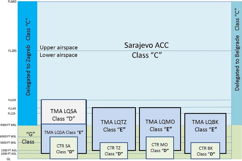
| FIC Banja Luka | Inside lateral borders of FIR Sarajevo, outside TMAs and CTRs. | 135.575 MHz | GND / 9500 FT AMSL | FIS |
| Unit | Area | Frequency | Vertical limits | Type of service |
| Sarajevo | CTR Sarajevo | 118.250 MHz | GND / 6500 FT AMSL | TWR, ADV, ADI |
| Banja Luka | CTR Banja Luka | 133.075 MHz | GND / 5500 FT AMSL | TWR, ADV, ADI |
| Mostar | CTR Mostar | 125.550 MHz | GND / 6500 FT AMSL | TWR, ADV, ADI |
| Tuzla | CTR Tuzla | 132.925 MHz | GND / 5500 FT AMSL | TWR, ADV, ADI |
| Unit | Area | Frequency | Vertical limits | Type of service |
| Sarajevo | TMA | 136.450 MHz | 1000 FT AGL / FL 205 | APS/RAD |
| Banja Luka | TMA | 133.075 MHz | 1000 FT AGL / FL 125 | APP |
| Mostar | TMA | 120.225 MHz | 1500 FT AGL / FL 145 | APP |
| Tuzla | TMA | 120.350 MHz | 1500 FT AGL / FL 145 | APP |
| Unit | Area | Frequency | Vertical limits | Type of service |
| RCC Banja Luka | FIR Sarajevo | Search and Rescue |
| 450912N 0170950E - 450804N 0170912E - 450342N 0170647E - 445753N 0170334E - 445013N 0170011E - |
| 444235N 0165729E - 443522N 0165457E - 443254N 0165405E - 441813N 0164859E - 435234N 0164016E - |
| along the border areas of flight information (Zagreb FIR/Sarajevo FIR) - 450912N 0170950E. |
| (Excluding TMA Banja Luka.) |
| 430230N 0173942E - 425336N 0175710E - 424808N 0180750E - 423500N 0183311E - |
| along the border areas of flight information (Beograd FIR and Sarajevo FIR) - |
| along the border areas of flight information (Zagreb FIR/Sarajevo FIR) - 430230N 0173942E. |
| 425336N 0175710E - 424808N 0180750E - 423500N 0183311E - |
| along the border areas of flight information (FIR Beograd and FIR Sarajevo) - |
| along the border areas of flight information (FIR Zagreb/FIR Sarajevo) - |
| 425135N 0175134E - 425336N 0175710E. |
| 425758N 0174115E - 425330N 0174728E - |
| west Along the border areas of flight information (FIR Sarajevo/FIR Zagreb) - |
| 425758N 0174115E. |
| 444114N 0191756E - 443547N 0190618E - 440812N 0191049E - 434624N 0191430E - 433154N 0190840E - |
| along the border areas of flight information between the Republic of Montenegro and Bosnia and Herzegovina - |
| 433049N 0185523E - 432838N 0184714E - 432055N 0184155E - 430834N 0183329E - 425944N 0182954E - |
| the border areas of flight information between the Republic of Montenegro and Bosnia and Herzegovina - |
| 423500N 0183311E - horizontally to the border areas of flight information between the Republic of Serbia and Bosnia and Herzegovina. |
| ACC | Area Control Centre or Area Control |
| ACFT | Aircraft |
| AD | Aerodrome |
| ADF | Automatic Direction Finding Equipment |
| AFIL | Flight Plan Filed in the Air |
| AFTN | Aeronautical fixed telecommunication network |
| AGL | Above Ground Level |
| AIC | Aeronautical Information Circular |
| AlP | Aeronautical Information Publication |
| AIS | Aeronautical Information Services |
| AMSL | Above Mean Sea Level |
| APP | Approach Control Office, Approach Control or Approach Control Service |
| ARO | Air Traffic Services Reporting Office |
| ATC | Air Traffic Services |
| CB | Cumulonimbus |
| CTA | Control Area |
| CTR | Control Zone |
| EET | Estimated Elapsed Time |
| ELT | Emergency Locator Transmitter |
| ENR | En-route |
| EOBT | Estimated off-block Time |
| FIC | Flight Information Centre |
| FIR | Flight Information Region |
| FIS | Flight Information Service |
| FL | Flight Level |
| FPL | Filed Flight Plan |
| GAC | General Aviation Centre |
| GAFOR | Forecast for General Aviation |
| GND | Ground |
| GPS | Global Positioning System |
| HPA | Hectopascal |
| ICAO | International Civil Aviation Organtzation |
| IAS | Indicated Air Speed |
| IFR | Instrument Flight Rules |
| INFO | Information |
| MWTOW | Maximum Take Off Wight |
| MSL | Mean Sea Level |
| NAV | Navigation |
| NM | Nautical Miles |
| NOTAM | Notice to Airman |
| NVFR | Night Visual Flight Rules |
| OPR | Operator |
| PIC | Pilot in Command |
| POB | Persons on Board |
| RWY | Runwav |
| SIGMET | Significant Meteorological Information |
| SR | Sunrise |
| SS | Sunset |
| SSR | Secondary Surveillance Radar |
| SVFR | Special Visual Flight Rules |
| SUP | AIP Supplement |
| TMA | Terminal Control Area |
| TWR | Aerodrome Control Tower or Aerodrome Control |
| UTC | Co-ordinated Universal Time |
| VFR | Visual Flight Rules |
| VMC | Visual Meteorological Conditions |
| VOLMET | Meteorological Information for Aircraft in Flight |
| VOR | VHF omni directional radio range |
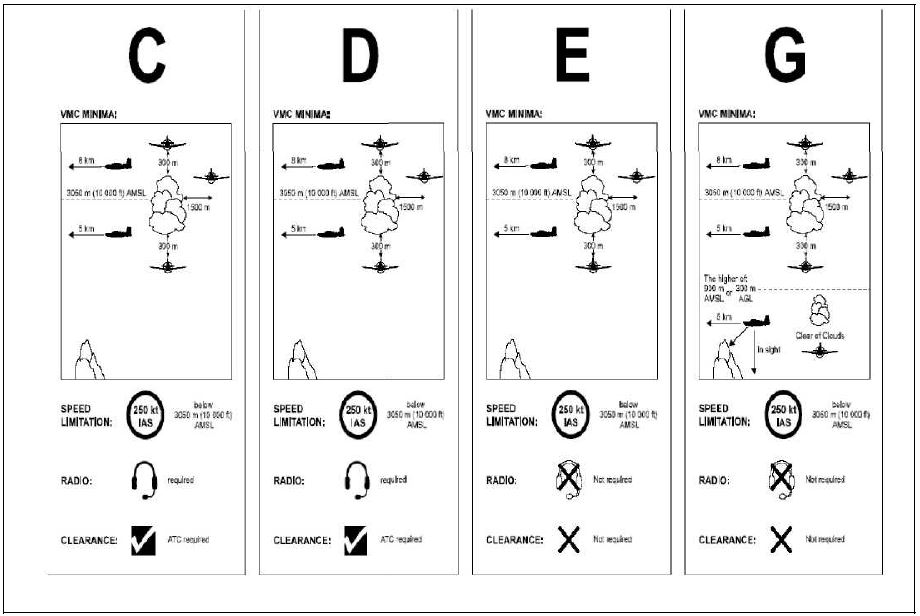
| Class | Type of flight | Separation provided | Services provided | Speed limitation | Radio communication requirement | Subject to an ATC clearance |
| A | IFR only | All aircraft | Air traffic control service | Not applicable | Continuous two-way | Yes |
| B | IFR | All aircraft | Air traffic control service | Not applicable | Continuous two-way | Yes |
| VFR | All aircraft | Air traffic control service | Not applicable | Continuous two-way | Yes | |
| C | IFR | IFR from IFR IFR from VFR | Air traffic control service | Not applicable | Continuous two-way | Yes |
| VFR | VFR from IFR | Air traffic control service for separation from IFR; VFR/VFR traffic information (and traffic avoidance advice on request) | 250 kt IAS below3 050 m (10 000 it) AMSL | Continuous two-way | Yes | |
| D | IFR | IFR from IFR | Air traffic control service; Traffic information about VFR flights (and traffic avoidance advice on request) | 250 kt IAS below 3 050 m (10 000 ft) AMSL | Continuous two-way | Yes |
| VFR | NIL | IFR/VFR and VFR/VFR traffic information (and traffic avoidance advice on request) | 250 kt IAS below3 050 m (10 000 ft) AMSL | Continuous two-way | Yes | |
| E | IFR | IFR from IFR | Air traffic control service and, as far as practical, traffic information about VFR flights | 250 kt IAS below3 050 m (10 000 ft) AMSL | Continuous two-way | Yes |
| VFR | NIL | Traffic information as far as practical | 250 kt IAS below3 050 m (10 000 ft) AMSL | No | No | |
| F | IFR | IFR from IFR as far as practical | Air traffic advisory service; flight information service | 250 kt IAS below3 050 m (10 000 ft) AMSL | Continuous two-way | No |
| VFR | NIL | Flight information service | 250 kt IAS below3 050 m (10 000 ft) AMSL | No | No | |
| G | IFR | NIL | Flight information service | 250 kt IAS below3 050 m (10 000 ft) AMSL | Continuous two-way | No |
| VFR | NIL | Flight information service | 250 kt IAS below3 050 m (10 000 ft) AMSL | No | No | |
| When the height of the transition altitude is lower than 3 050 m (10 000 ft) AMSL, FL 100 should be used in lieu of 10 000 ft | ||||||
| TRACK ** | |||||||||||
|---|---|---|---|---|---|---|---|---|---|---|---|
| From 000 degrees to 179 degrees*** | From 180 degrees to 359 degrees*** | ||||||||||
| IFR Flights | VFR Flights | IFR Flights | VFR Flights | ||||||||
| Level | Level | Level | Level | ||||||||
| FL | Feet | Metres | FL | Feet | Metres | FL | Feet | Metres | FL | Feet | Metres |
| 010 | 1000 | 300 | 020 | 2000 | 600 | ||||||
| 030 | 3000 | 900 | 035 | 3500 | 1050 | 040 | 4000 | 1200 | 045 | 4500 | 1350 |
| 050 | 5000 | 1500 | 055 | 5500 | 1700 | 060 | 6000 | 1850 | 065 | 6500 | 2000 |
| 070 | 7000 | 2150 | 075 | 7500 | 2300 | 080 | 8000 | 2450 | 085 | 8500 | 2600 |
| 090 | 9000 | 2750 | 095 | 9500 | 2900 | 100 | 10000 | 3050 | 105 | 10500 | 3200 |
| 110 | 11000 | 3350 | 115 | 11500 | 3500 | 120 | 12000 | 3650 | 125 | 12500 | 3800 |
| 130 | 13000 | 3950 | 135 | 13500 | 4100 | 140 | 14000 | 4250 | 145 | 14500 | 4400 |
| 150 | 15000 | 4550 | 155 | 15500 | 4700 | 160 | 16000 | 4900 | 165 | 16500 | 5050 |
| 170 | 17000 | 5200 | 175 | 17500 | 5350 | 180 | 18000 | 5500 | 185 | 18500 | 5650 |
| 190 | 19000 | 5800 | 195 | 19500 | 5950 | 200 | 20000 | 6100 | 205 | 20500 | 6250 |
| 210 | 21000 | 6400 | 215 | 21500 | 6550 | 220 | 22000 | 6700 | 225 | 22500 | 6850 |
| 230 | 23000 | 7000 | 235 | 23500 | 7150 | 240 | 24000 | 7300 | 245 | 24500 | 7450 |
| 250 | 25000 | 7600 | 255 | 25500 | 7750 | 260 | 26000 | 7900 | 265 | 26500 | 8100 |
| 270 | 27000 | 8250 | 275 | 27500 | 8400 | 280 | 28000 | 8550 | 285 | 28500 | 8700 |
| 290 | 29000 | 8850 | 300 | 30000 | 9150 | ||||||
| 310 | 31000 | 9450 | 320 | 32000 | 9750 | ||||||
| 330 | 33000 | 10050 | 340 | 34000 | 10350 | ||||||
| 350 | 35000 | 10650 | 360 | 36000 | 10950 | ||||||
| 370 | 37000 | 11300 | 380 | 38000 | 11600 | ||||||
| 390 | 39000 | 11900 | 400 | 40000 | 12200 | ||||||
| 410 | 41000 | 12500 | 430 | 43000 | 13100 | ||||||
| 450 | 45000 | 13700 | 470 | 47000 | 14350 | ||||||
| 490 | 49000 | 14950 | 510 | 51000 | 15550 | ||||||
| etc. | etc. | etc. | etc. | etc. | etc. | ||||||
| Altitude band | Flight visibility | Distance from cloud |
|---|---|---|
| 10000 FT(3050m) Below 10000 FT (3050 m) | 8 km 5 km | 1500 m horizontally 300 m (1000 FT) vertically |
| Altitude band | Flight visibility | Distance from cloud |
|---|---|---|
| 10000 FT(3050m) Below 10000 FT (3050 m) | 8 km 5 km | 1500 m horizontally and 300 m (1000 FT) vertically |
| At or below 3000 FT AMSL or 1000 FT above terrain, whichever is higher | 1,5 km for aircraft800 m for helicopters, airship and unnamed free balloon at speed, in the prevailing visibility, will give opportunity to observe other traffic or any obstacles in time to avoid collision | Clear of cloud and with the surface in sight |